


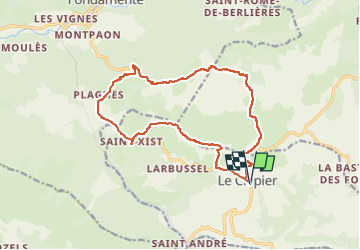
Le Clapier - Guilhaumard Jardin botanique e St Sixct

Alain28/01
User

Length
16.6 km

Max alt
798 m

Uphill gradient
375 m
Km-Effort
22 km

Min alt
625 m

Downhill gradient
375 m
Boucle
Yes
Creation date :
2024-11-12 17:07:14.492
Updated on :
2024-11-12 17:09:06.324
4h54
Difficulty : Difficult

FREE GPS app for hiking
 SityTrail
IGN / Geographical institutes
SityTrail Plus
The world is yours!
About
Trail Walking of 16.6 km to be discovered at Occitania, Aveyron, Le Clapier. This trail is proposed by Alain28/01.
Positioning
Country:
France
Region :
Occitania
Department/Province :
Aveyron
Municipality :
Le Clapier
Location:
Unknown
Start:(Dec)
Start:(UTM)
513950 ; 4853062 (31T) N.
Comments